Deutsch

Regional Water Resources Management for Sustainable Protection of Waters in Germany
HyMoBioStrategie
Impact of the hydromorphological changes of lakeshores (Lake Constance) on the sediment budget, submerged macrophytes and macro-invertebrate communities with the goal of optimising mitigation strategies
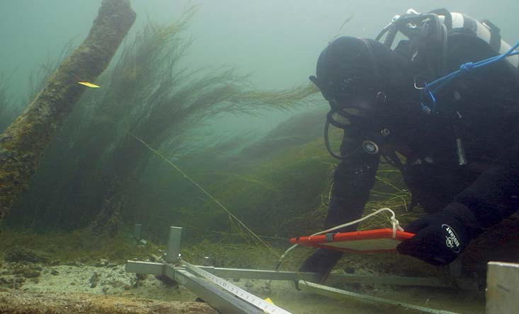
MEASURES TO PROTECT THE SHORES AND UNDERWATER MONUMENTS OF LAKE CONSTANCE
In the last decades, many pre-alpine and alpine lakes have seen increased erosion of littoral sediments. This process is endangering underwater monuments (i.e. pile dwellings) designated as UNESCO World Heritage Sites, among others. It is hypothesised that mainly anthropogenic intervention is accountable for the observed hydromorphological changes in littoral zones. Lakes in Germany are used in a variety of different ways. Demands with regard to use often go hand-in-hand with a significant structural impact due to shore construction, i.e. bank reinforcements or harbours, with lake uses in the form of recreational sporting activities, and with shipping. This leads to modifications of the hydrodynamic conditions in the littoral zone which in turn impacts the transport and balance of solid substances and the submerged macrophyte and macro-invertebrate communities. The joint project HyMoBioStrategy focuses on developing solutions and strategies to improve the ecological status of the shores and littoral zones as well as on recommendations for a sustainable management in lakes.
GOALS
The goal of the joint project is to study and assess anthropogenic hydromorphological changes in the littoral zone within the meaning of the European Water Framework Directive (WFD), and to develop intervention programmes which address the littoral zone for sustainable shore management and restoration. The focus is on:
- Contributing to the sustainable development and management of littoral zones in lakes
- Improving methods for assessing the ecological status of lakes according to the WFD and with the help of biotic indicators for the littoral zone
- Providing a measurement system for horizontally resolved, fine-scale measurement of lake bottom topography and sediment structure
- Methods to characterise and quantify the transport of solid substances in the littoral zone of lakes
- Monitoring large-scale sediment redistribution within the range of underwater monuments
- Effective and environmentally viable protection of underwater monuments belonging to the UNESCO World Heritage “Prehistoric pile dwellings around the Alps”
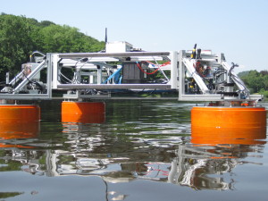
Prototype of the “Hydrocrawler”
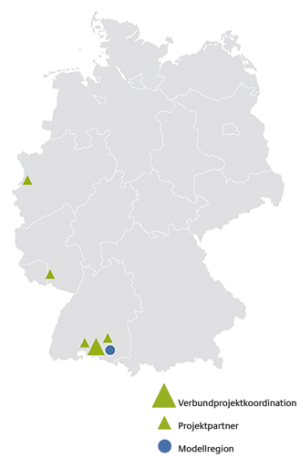
Model Region
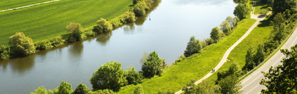
Research will take place on the northern shore of Upper Lake Constance at six selected study areas with different characteristics. Geographically, Lake Constance is situated in the foothills of the Alps and is fed mainly by the Alpine Rhine River.
Key messages
- Development of a sediment transport model as a forecast tool to help plan future measures on shorelines and assess their impact on the hydro- und morphodynamics in the littoral zone of lakes
- New methods characterising and quantifying the sediment transport in the littoral zone of lakes have been established and are available for use
- Development of the universally applicable, autonomous monitoring vehicle Hydrocrawler, e.g. for the high-resolution, comprehensive survey of the lake bottom topography and sediment stratigraphy
- Improvement of the methods used to assess the ecological status of lake shores in line with the WFD using the two biotic indicators macrophytes and macrozoobenthos
- Further refinement of the quality- and monitoring standards in the course of lake shore renaturations based on the renaturation guideline of the International Commission for the Protection of Lake Constance (IGKB)
- Recommendations for a sustainable management of littoral zones of lakes while considering the existing intensive usage claims and sustainability conflicts
Further Information
Kontakt
-
Universität Konstanz
Limnologisches Institut, Arbeitsgruppe Umweltphysik
Dr. Hilmar Hofmann
T: +49 7531 88 3232
M: hilmar.hofmann@uni-konstanz.de