Deutsch

Regional Water Resources Management for Sustainable Protection of Waters in Germany
BOOT-Monitoring
Boat-based measurement system to map the longitudinal morphometry, water quality and hydrology profiles of rivers as part of an integrated river monitoring system
CONTINUOUS MONITORING OF RIVERS BY BOAT
All ground- and surface water bodies in Europe must achieve an environmental and chemical status defined as “good” by the year 2027 at the latest. That is the stated goal of the European Water Framework Directive (WFD) and it applies to all groundwater- as well as to coastal and surface water bodies. Extensive measurement and evaluation programmes are needed in order to evaluate the current status of water bodies and to plan interventions. Up till now, a river’s water quantity and
-quality is measured only at specific sites which are representative for a segment of the river. This method has its drawbacks: Data is interpolated in order to be able to make an assessment of a river’s properties and of its status between the individual measuring sites. During this process, difficult to verify assumptions need to be made about how data values may change, thus leading to errors in assessing pollution and its causes. The partners of the joint project BOOT-Monitoring want to change that. With the help of online sensors mounted on a boat, the water quality, channel morphometry and hydrology parameters along the river’s course will be continuously mapped.
GOALS
The goal of the joint project BOOT-Monitoring is to enable the status of small and mid-sized streams and rivers in Germany to be better described and assessed, so that the rivers can be managed more sustainably. The project will focus on the following tasks:
- Collecting exact spatial and temporal water quality and morphology data along segments of urban and natural rivers
- Describing a river’s hydromorphological status and water quality within the framework of the environmental status classification system of water bodies
- Identifying vulnerable river segments and critical situations with regard to pollution
- Heightening the impact of river monitoring currently done by regional authorities, in accordance with the goals of the WFD
- Evaluating measures to manage and develop rivers based on better data from simulation models
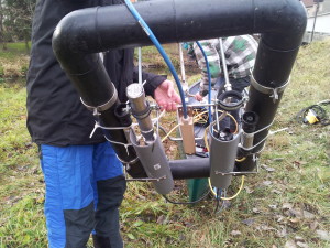
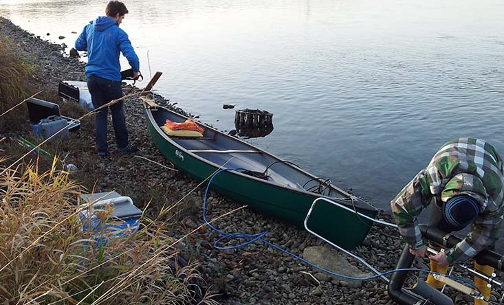
Outdoor tests with a prototype of the boat-based measurement system
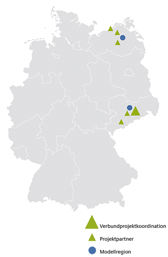
MODEL REGIONS
The joint project will study two model regions: The ‚Freiberger Mulde‘ serves as a model for rivers in low mountain ranges. The river Tollense is a model for rivers in lowlands, its lower reaches have been substantially modified by human activity. There are also plans to study other model regions within the framework of a cooperation with the joint project RiverView.
Key messages
- A monitoring concept was developed with which small to middle-sized streams and rivers can be navigated along their course, even when water levels are low or there is vegetal invasion. The monitoring system is structured in a modular fashion. If combined with an efficient navigation strategy, it can be adapted to specific evaluation criteria.
- The spatial-temporal high-definition measurement of physical-chemical water parameters allows specific point- or diffuse pollution sources to be identified and described, as well as determining degradation processes in the water body. This makes it possible to develop targeted measures to reduce pollution and to make water management more efficient.
- New evaluation algorithms to describe the river morphology on the basis of boat-based, georeferenced sensor technology and possibly drone- or satellite-based information enable improved evaluation of the structure of streams and rivers for the Water Framework Directive (WFD).
Further Information
Kontakt
-
Technische Universität Dresden
Professur für Siedlungswasserwirtschaft
Prof. Dr. Peter Krebs
T: +49 351 463 35257
M: peter.krebs@tu-dresden.de -
Stefanie Wiek
T: +49 351 463 40544
M: stefanie.wiek@tu-dresden.de